That’s the new screen saver sorted.
2 Likes
Confirmation (if any were needed) that there are loads of tits on this forum.
3 Likes
Take South Korea as an example then instead of NZ. None of those factors you have listed are on their side. Higher population density, slightly smaller total population, similar levels of urbanisation, and was at the epicentre of the first wave due to its proximity to China. Higher average age of the population as well.
82,000 cases and 1,496 deaths vs UK’s 4m cases and 115,000 deaths.
UK’s response, like a good proportion of European countries, was truly pathetic. And in the summer months when the opportunity was there to, not necessarily avoid a second wave but to minimise its damage, they spent all their energies on trying to recover the economy.
UK government is like a bad alcoholic. Continuing to regress into old habits.
5 Likes
Which perversely (like the eat out to help out campaign) made thing actively worse.
1 Like
AGAIN. YET AGAIN.
At no point am I saying that the UK could not have done more to help itself. It quite clearly could and should have done!!!
EVERYONE GET IT NOW?

South Korea acted promptly, aggressively, directing a high degree of technology at the problem, and with the benefit of experience from dealing with SARS. I’m not sure that the UK could have gone quite as far as South Korea (below) for various reasons but it undoubtedly could and should have been much more proactive.
2 Likes

2 Likes
Curious where you got the density numbers for London - might be a London versus Greater London discrepancy, as I saw rather lower.
But the problem with the density point is simply that it doesn’t have a great deal of explanatory power even within England. London has had fewer cases per capita than several other areas with lower densities.
One element that should have been in the UK’s favour is being an island, which means more control over the borders is intrinsic. But working against that is the massive interdependent traffic. It would have been one thing to shut down Heathrow, not doing so was a political/economic choice. But I think the first week or so of this year illustrated what a massive challenge shutting down or even controlling/testing land and sea traffic would have been.
However, I do think policy is the overwhelming determinant. It is frustrating as a missed opportunity to see just how well our Maritime provinces have done. They have a couple of advantages, density and urbanisation being low is one set, but the determination to contain and eradicate has been the critical difference. Due to the number of land crossings, they have not been able to return to normal - New Brunswick is directly connected to Quebec, the worst-hit province, but they have intervals of days with no new cases.
Once a jurisdiction gets numbers down and controls inflows, a lot of good policy becomes possible. UK testing and sequencing has been world-leading, contact tracing has been woeful. But working at orders of magnitude lower would improve that. In Nova Scotia now, if you want a test, you call and a car picks you up. Contagion risk is controlled right from the point of the phone call. A colleague at Acadia U was tested in the morning and had his results mid-afternoon. With the sheer mass of laboratory capacity, per capita far higher in the UK than NS, something like that could have been possible.
That in turn is showing in the economic performance. Their regional economy has inevitably taken a hit, largely due to tourism, but nowhere near the sort of percentage seen elsewhere in Canada or the UK. A pundit asked sarcastically if they could have improved their economic performance by having a little more coronavirus.
2 Likes
I think it was wikipedia:
But equally USA today has 13,210 per square mile (5,100 per square km)
World Population Review has the density at 14,550 per square mile (5,617 per square km)
https://worldpopulationreview.com/world-cities/london-population
But you’re right, and I’ve acknowledge many times, it is only one factor.
It was indeed the London Metropolitan region I was initially viewing (1,510 per km2) - the wikipedia has both numbers.
1 Like
Ok, having been out on the bike, cooled down (it’s freezing out), showered and in the process of being fed and watered here are the basis of my thoughts.
I dont think the demographics are largely irrelevant until you are in the position where you can state that the headline management of the pandemic is similar between two nations. Basically, I believe they only form a small proportion of the figures (however you wish to measure them) when compared to the overall management strategy. If they aren’t the only real things that matter is deaths, cases, death rate etc.
in some ways its like trying to measure success between City and say Southampton.
We’re looking at a much larger population then. Greater London population 8,961,989, with a population density of 5,666/km².
London Metropolitan Region population of 13,709,000 and a population density of 1,510 per square kilometre (approximately 9 times the population of Auckland (nearly 3 times the total population of New Zealand) and at a greater population density than New Zealand’s most densely populated urban area).
Anyway…I’ve made my point. It’s a factor among many, many, many others and is certainly not the most important one.
1 Like
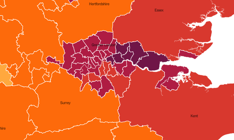
Looking at the boroughs, it is interesting to see case distribution - not sure if that is the early B117 and now the Kent variant at work. Per capita the eastern suburbs of London are some of the worst hit areas of the country. I don’t know London well enough to identify whether they are in the 13.7M and not the 8.9M.
South Wales has some scary spots as well.
These are the boroughs that constitute Greater London
I don’t know the London area well enough to pick out where Havering and Bexley are vis-a-vis some of the other areas on a map of the whole UK is probably a better way to put it - the whole belt to the east and southeast shows pretty dark on a gradient map of cases per 100K.
Liverpool is another not-pretty looking area. It is actually hard to get my mind around what that must be like. Montreal at peak sounded awful, but it is not even in the same magnitude as the Merseyside area.
1 Like
Ah, Havering is no.24 on the map and Bexley no.23. Bexley finishes just to the west of Dartford, if that helps? Havering includes Romford but doesn’t go as far as Brentwood.
1 Like
If I drill down far enough, eventually. I presume Thurrock is still somewhat suburban in the western end?
1 Like
Yes, Thurrock is outside of Greater London but I imagine it would be included in the London Metropolitan Area…that boundary (LMA) I’m not sure of although it must be set out somewhere!
1 Like
1 Like